

The Story of Joel Carolus Doolittle
A One Shot at History article — Carl G. Reinemann
In December of 1845, a thirty-year-old carpenter from Danby, New York, walked along a stretch of rapids on the Rock River that nobody had yet bothered to give a permanent name. The place had been called Indian Ford, then Doty’s Grove, then Hubbard’s Rapids, after a New Hampshire governor who had never set foot on it. There was no dam, no mill, no store, no road worth the name — just the river running fast over a shelf of rock, a scattering of Winnebago wigwams along the banks, and a lot of very good timber.
Joel Doolittle picked a spot on the west side of the river and built a log shanty. His wife, Palmyra, and children joined him. And with that unremarkable act — a man cutting logs for a one-room cabin in the middle of nowhere — Horicon, Wisconsin, got its first permanent citizens.
The seeds of town, along the Rock River, were about to sprout.
Before the Rapids Had a Name
The site Doolittle chose had been inhabited for a very long time before he got there. Effigy and burial mounds lined the riverbank; Winnebago corn hills, planted in the same spots year after year without plowing, were still visible to the first settlers. The village on the site — known variously as Hochurunga (“fish eaters”), Maunk-shak-kah (“White Breast”), and Parachera (“fire village”) — had been home to roughly 2000 people as recently as 1820, one of fourteen Ho- Chunk (Winnebago) settlements strung along the Rock River.
White surveyors had been circling the spot for years without settling it. In 1838, Job Perry and Solomon Juneau picked out a “witness tree” – a large oak tree as a future dam site but never built anything. In 1839, Surveyor David Giddings purchased a mile-long strip of land along the Rock River. That same year, Governor Henry Hubbard of New Hampshire bought up Giddings land, and a claim of nearly 500 acres covering most of what’s now the south side of the village, sight unseen, through an agent. He later sold part of it to John B. Preston, William Larrabee and others for “town and water site purposes,” and the place picked up the name it would carry until 1846: Hubbard’s Rapids.

None of that made it a town. What made it a town was somebody actually staying.
How the Land Changed Hands
The ground under Joel Doolittle’s shanty had been signed away thirteen years before he arrived, in the wake of a war the Ho-Chunk had not started. In the summer of 1832, during the Black Hawk War, Winnebago at Fort Winnebago told the army where Black Hawk’s band was hiding: at the rapids of the Rock River, near present-day Hustisford, just a few miles downstream from Horicon. Most Ho-Chunk had stayed out of the fighting. The government decided to move them away from the settlements anyway. In September 1832, their chiefs were called to Fort Armstrong, where General Winfield Scott and Illinois Governor John Reynolds secured the cession of all their land south of the Fox-Wisconsin waterway.
The treaty’s boundary is the part that matters for Horicon. The cession line began at the mouth of the Pecatonica and ran up the Rock River to its source, which made the river itself the property line. Everything on the west bank, including the spot Doolittle would choose, passed to the United States in 1832. The east bank followed a year later, when the united Chippewa, Ottawa, and Potawatomi ceded their land between Lake Michigan and the Winnebago cession of Fort Armstrong at Chicago in September 1833. In return, the Ho-Chunk received the “Neutral Ground” in Iowa, a tract that sat close to the Sioux and the Sauk and Fox, tribes still at war with one another. They also received $10,000 a year for twenty-seven years, a school, and farmers to teach agriculture, and the Rock River band was promised 1,500 pounds of tobacco annually. The exchange was to be completed by June 1, 1833. The winter that followed was one of great hardship for the Winnebago. Treaty with the Winnebago, 1832 +4
A signature in Rock Island did not empty the Rock River country. Many Ho-Chunk simply stayed or came back. One trader married into the family of Whirling Thunder was suspected of advising the Winnebago to return to the Rock River country in 1833. An 1837 treaty negotiated in Washington, D.C., claimed all remaining Ho-Chunk land in Wisconsin for the United States, and still families remained. Dodge County’s own 1880 history admits that Winnebago people were still in the area in 1844–45. So when Doolittle walked the rapids in December 1845 and saw wigwams along the banks, he was looking at people the government now counted as trespassers on their own homeland. Forced removals continued for decades, but the Ho-Chunk never fully left. The Ho-Chunk Nation of Wisconsin is still here today, and in 1975 the Winnebago Tribe of Nebraska was awarded $4.6 million by the Indian Claims Commission for land lost in the 1837 cession.
The First Cabin
That somebody was Joel Carolus Doolittle. Every history of Horicon written since — the 1880 History of Dodge County, a slew newspaper retrospectives, the 1948 History of Horicon, and my own research today — agrees on the essential point, even where they disagree on the details: Doolittle was Hubbard’s Rapids’ first actual, permanent settler, and Palmyra was the first white woman on the ground.
The 1880 county history puts it plainly:
“The first actual and permanent settler at the Rapids was Joel Doolittle, and Mrs. Doolittle, who is still alive, has the honor of having been the first white woman upon the ground. In December 1845, Mr. Doolittle made a claim and built a log shanty on the west side of the river, just south of the present site of H. B. Marsh’s brick mill.”

Local histories place the Doolittle cabin on the hill just north of where the Octagon House now stands, above the river and the original Ho-Chunk village. Wherever exactly it stood, it was the first roof built by a European settler at the Rapids — and for a while, the only one.
Modern GIS mapping bears this out: geocoded against the actual survey grid, these local histories land within about a 800 feet of each other — different landmarks pointing at essentially the same stretch of riverbank.
A Dam Too Big to Finish
Doolittle wasn’t just squatting on good land. He had a job to do. Before he’d even finished the cabin, he’d signed a contract with the men who owned the water rights to the Rock River — William Larrabee, John Preston, and Martin Rich of Juneau — to build a dam across the Rock River for $700.
It didn’t go well. A dam across a river the size of the Rock, built by hand with 1845 tools, turned out to be a much bigger job than $700 covered. Doolittle spent, in the county historian’s words, “considerable time and labor upon the project” before admitting his estimate was too low. By general agreement, he was released from the contract and walked away. Martin Rich took over, hired a crew from Milwaukee and finished the dam that winter.
It’s a small, almost funny footnote — the first settler undone by his own bid — except that it isn’t really a footnote at all. That dam, once finished, is the reason Horicon exists in anything like its present form. It backed up the Rock River into what became Lake Horicon (and, later, again, the marsh); it powered the sawmills and gristmills that turned a rapids into a village; it’s the reason the site was worth naming at all. Doolittle helped set that whole chain of events in motion, even though he didn’t get to finish the job himself. A local newspaper retelling the story ninety years later, in 1937, still thought it worth passing on — evidence of how central the Doolittle name was to how Horicon remembered its own beginning.
The dam and the mill that rose beside it kept turning up in the record for years afterward. An 1853 Jefferson County court notice — a sheriff’s sale settling accounts among several of the water site’s own investors — lists both William M. Larrabee and H. B. Marsh among the parties, still holding shares of “the double saw mill and mill dam and water power” eight years after Doolittle had walked away from his contract. The notice even locates the property precisely: an acre of ground “lying at the south end of the mill dam.” That description lines up almost exactly with where the 1873 village atlas draws the dam itself — a heavy line crossing the river right at the bend in Front Street, with a grist mill built immediately downstream of it. It’s a small, dry piece of legal boilerplate, but it’s an independent, dated confirmation that the dam Doolittle started building sat exactly where local memory has always placed it, just south of the Vine Street bridge, at the present site of the Blue Heron Landing.
Neighbors in the Wilderness
For the first year or two, Doolittle and his family had the place nearly to themselves. It was the summer and fall of 1846 before the next wave of settlers — George H. Beers, H. B. Marsh, S. N. Rice — arrived and put down roots. One of those newcomers, Mrs. George H. Beers, later wrote a series of reminiscences about the settlement’s earliest days that give us the best surviving picture of what life at the Rapids actually looked like around the time the Doolittles were its only white residents:
“This place was wild, yet beautiful. It was formerly an Indian planting-ground, and many of their corn hills are still visible… Indian ponies grazed around the house all night, and their bells kept up a constant tinkling. The fear of the Indians troubled me somewhat… but here they seemed harmless… Oft times, while about my work, I would look up to see dark faces peeping in at my window, as that was their habit always before entering a house.”
By 1846 there was enough of a settlement for a school — held in a cabin, with Doolittle’s own son among the first pupils — and enough families that Mrs. Doolittle herself was one of the pioneer women organizing early school meetings, alongside Mrs. Chandler. Doolittle wasn’t just the man who happened to arrive first and build a cabin. He and Palmyra were, for a couple of years, more or less the entire civic infrastructure of the place — parents, builders, and de facto founders of whatever passed for a school board.
The Chandlers, it turns out, ran on a parallel track to the Doolittles for decades. J. H. Chandler arrived with his wife and children in the fall of 1844 and settled in Oak Grove — at the time the established little settlement a few miles southwest of the Rapids, and the nearest post office anyone in the area had before Horicon got its own in 1847. He claimed land in Section 1 there, built the first brick house in Dodge County, and he and his sons ran the county’s first brickyard, supplying the brick that went up in Juneau’s and Horicon’s earliest public buildings. His son, Isaac H. Chandler, grew up along that stretch of river and later gave his own eyewitness account of Indian burial grounds near the railroad crossing — testimony that survives in the same 1880 county history that preserved Doolittle’s story. By 1873, a Chandler still held over a hundred acres one section south of that original claim, in Section 12 — the same square mile where Doolittle’s own forty acres sat. And back in the village, it was Mrs. Chandler who worked alongside Mrs. Doolittle organizing the first school meetings. The two families’ paths kept crossing: neighbors in Oak Grove, neighbors in the village, and, it turns out, practically neighbors on the specific 40 acres that Doolittle received by patent in 1848.
Making It Official
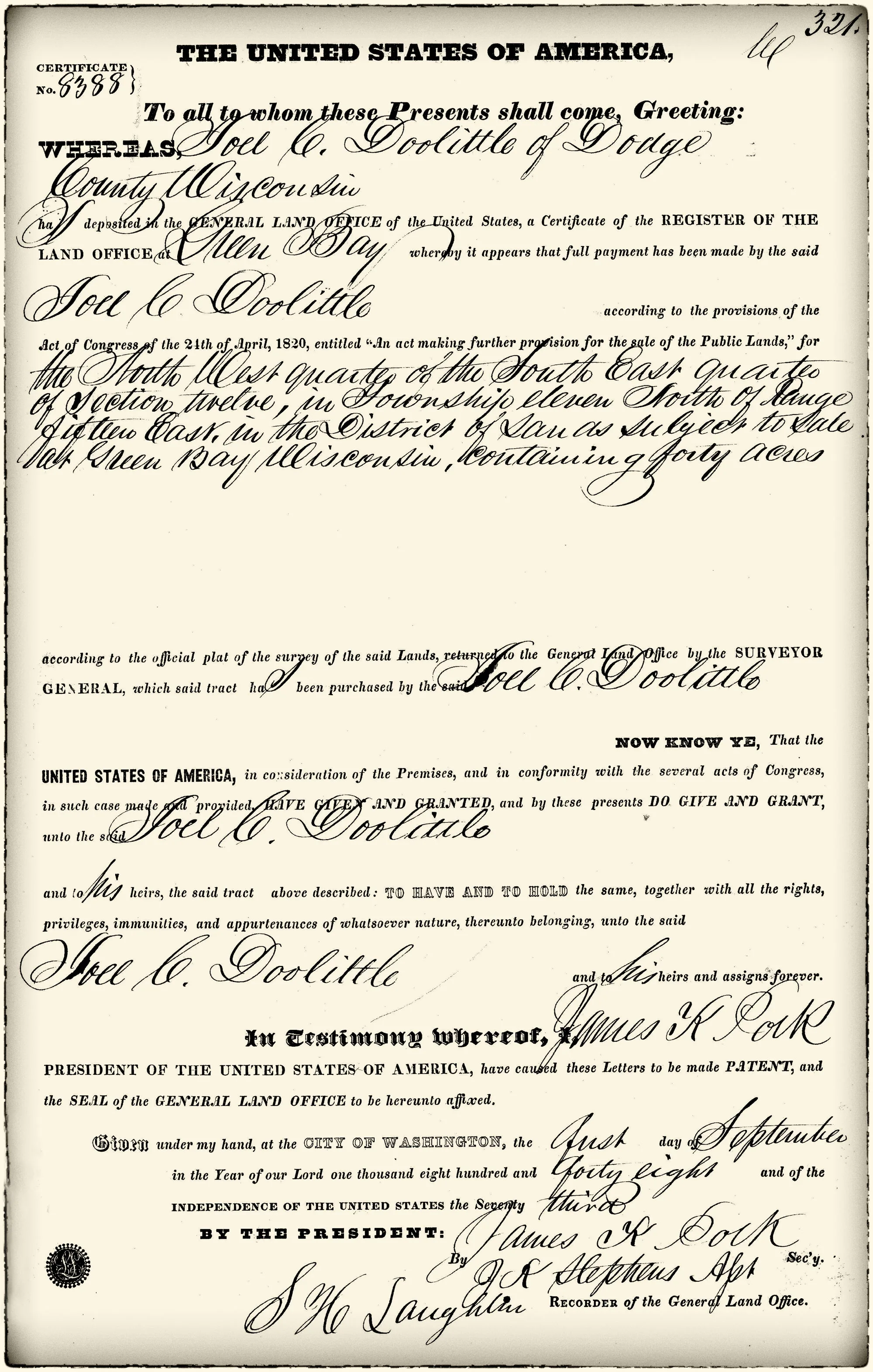
Squatting on a claim was one thing; owning it was another. On September 1, 1848, Doolittle’s claim was formalized by the federal government. A General Land Office patent — Certificate No. 8388, issued through the Green Bay Land District — granted him forty acres in the northwest quarter of the southeast quarter of Section 12, Township 11 North, Range 15 East, signed, as all such patents were, in the name of the sitting president. In this case that was James K. Polk, whose signature still appears on the document today.

It’s a small piece of paper, but it marks the moment Doolittle’s claim stopped being a matter of who got there first and started being a matter of federal record — the earliest recorded private landholding within what’s now the Horicon city limits.

The forty acres were finally a separate farm claim, formalized three years after Doolittle had already built, settled, and helped found the town by the river.
Public Life in Dekorra, and a Return Home
For a few years in the late 1840s, the Doolittle family’s fortunes shifted west to Dekorra, in Columbia County, where Joel took up carpentry and joinery and, briefly, local office. An 1849 election there sent him in as constable; a second election that spring made him town treasurer. By the 1850 census, the family was settled in Dekorra, Joel’s occupation recorded simply as “carpenter & joiner.”
They didn’t stay away. By the early 1850s the Doolittle’s were back in Horicon, where several more of their children were born, and where Joel farmed hi 40 acres, and picked up work again as a lumber merchant and builder — the trade that had brought him to the Rock River Rapids in the first place.
An Early Death

Joel Doolittle died at Horicon on September 6, 1856. He was forty-one years old. He was buried at Oak Hill Cemetery, in the town he’d helped start eleven years earlier. His youngest son, Hubert Joel, born the previous December, followed him in death just three months later.
Palmyra outlived him by decades. The Dawson family genealogy has her still living in Horicon as of 1873; the 1880 county history speaks of her, in the present tense, as “still alive” — the same woman once described as the first white woman ever to set foot on the ground that became Horicon, still there to be asked about it more than thirty years on.
Of their eight children, four were still living in or near Horicon and Oshkosh as of 1873: Wealthy Josephine, a teacher in Horicon; Sylvester Legrand, in Oshkosh; Floyd Legranson and Frances Adalene and Emma Elizabeth, were all still in Horicon.
Legacy
Joel Doolittle never got to see the town he started. He died the year the railroads arrived and Horicon’s population passed six hundred — the year Van Brunt’s seeder was still five years off, when the dam he’d tried and failed to build was already a decade old and had, by then, backed up an entire lake behind it. He didn’t build the mills, or the churches, or the Van Brunt seeder company that would eventually make Horicon a manufacturing town known well beyond Dodge County.
What he did was simpler and, in its way, more essential: he showed up first, built a cabin, and stayed. Every history of Horicon written in the century and a half since — the 1880 county history, a 1937 newspaper column revisiting the town’s founding for readers two generations removed from it, and the research pulled together for this piece — comes back to the same sentence, almost word for word: Joel Doolittle was Horicon’s first actual, permanent settler. It’s not a large claim to fame. But it’s the one thing every subsequent building, business, dam, and family in this town’s history had to happen after.
Sources used:
- History of Dodge County (Western Historical Co., 1880), Ch. VIII; “Why Did They Name It Hubbard Township,”
- Waupun Leader-News, Oct. 14, 1937;
- Dawson family genealogy (1874), entry 6-107;
- GLO patent no. 8388 (1848) and BLM/GLO official patent-details record;
- Wisconsin State Register, June 17, 1876;
- 1873 Dodge County Atlas (Foote & Henion) — Horicon, Hubbard, and Oak Grove township plats;
- Jefferson County Circuit Court sheriff’s sale notice, Burr v. Larrabee et al., March 17, 1853;
- C. Reinemann’s compiled Horicon-history research, including “Horicon Timeline of history.”
