
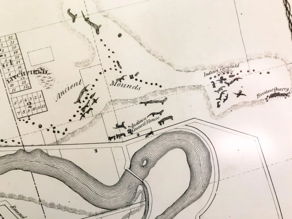

Click here to learn more about this map
Why this map, and why now
Long before Horicon, Watertown, Janesville or Rockford had names, the Rock River was home. Villages stood on its banks. Cornfields and gardens ran along its terraces. Trails followed its valleys, and mounds rose on the ridges above the water.
For the past several monthss I have been building a map to bring that world back into view. It is called Where the Rivers Were Home: Native Homelands of the Western Great Lakes. My goal was to have it mostly ready for Native American Heritage Month this November.
I’ll be honest: it is not finished, and it may never be. There is A LOT of data out there, scattered across old atlases, survey plats, archaeology journals, treaty records and village lists. Every piece has to be found, checked, placed on the map and properly credited. That last part matters most to me.
What you will find on the map
The heart of the map is the Rock River, one of my focuses on local history near me, from its headwaters in the Horicon Marsh to its mouth at the Mississippi, with its West, South, and East Branches. From there it reaches out across Wisconsin and Illinois.
- Villages and sites: Hocąk (Ho-Chunk), Potawatomi, Sauk, Menominee, Ojibwe and other villages, camps, cornfields and gathering places, many with chiefs, lodge counts and populations from the 1829–32 records.
- Mounds: named mound groups you can visit, plus the effigy and conical mounds plotted on Charles E. Brown’s 1916 map and the Wisconsin First Nations map.
- Trails and trade routes: old foot trails from four sets of maps, fur trade water routes and the portages between them.
- Forts, trading posts and missions around 1830, and the sites of the Black Hawk War of 1832.
- Treaties and tribal lands: every land cession touching Wisconsin or Illinois, with a year slider to watch the land go, plus today’s reservations and trust lands. The former Eeyamquittowauconnuck – Brothertown Indian Nation reservation on Lake Winnebago is included too, even though the Brothertown are not federally recognized.
- Historic maps you can fade in and out over the modern one.
Click any point, line or shaded area and a card tells you what the record says and where it came from.
The map by the numbers
Mound sites make up the largest share of the map
2,295 places, routes and areas so far, by kind (reference counties and rivers not counted)
| Measure | So far |
|---|---|
| Map layers you can turn on and off | 37 |
| Old trails digitized | about 5,970 miles |
| Fur trade water routes | about 2,975 miles |
| Rock River and branches | 365 miles |
| Land cession treaties | 54, from 1795 to 1854 |
| Historic maps fitted in Allmaps | 15, pinned at 149 control points |
| Sources cited on the site cards | dozens, from 1820s village rolls to 2026 park pages |
| Burial and restricted records online | 0 |
Counted from the map’s data, November 12, 2026.
Getting it right, and saying when we can’t
Every attempt was made for accuracy. Where the information was vague, or still is, the map says so.
- Every card names its sources. Where I could, I pointed to the original record or an official source: the Wisconsin Historical Society, the National Register, state and county parks, tribal nations, and the old surveys and atlases themselves.
- Every site says how it was located and, where known, how sure that is. About 330 locations are marked approximate, and 15 carry low certainty. A village placed from a vague 1830s description is not the same as a mound group with a park sign, and you deserve to know the difference.
- Spellings follow the sources. Old records called the Ho-Chunk “Winnebago” and the Ojibwe “Chippewa” or “Ojibwa.” The cards give the name a nation uses today alongside the name in the record.
- Old maps are guides, not surveys. I pinned each scanned map to the modern map at places found on both, like river mouths, forts and towns. Between those points an old map still drifts.
Some things are deliberately left off. Burial records, human remains, relics and restricted archaeological site files stay in a private part of the project and are never put online. Named mound sites on private land with no public access were left off, and the map gives no walking routes onto private land. These places are sacred to living nations, and they deserve that respect.
Still to come
This is a living map. Next up are statewide villages, portages and long-distance trails for all of Michigan from W. B. Hinsdale’s 1931 Archaeological Atlas of Michigan, more trails, and more sources for sites that still rest on a single reference.
If you know a site, a source or a family story that belongs here, or you spot something I got wrong, please tell me. Corrections are welcome, especially from the nations whose history this is.
Explore the map at oneshotathistory.com/maps/native_presence, and find all my maps on the Wisconsin History Maps page.
Because the past only happens once.
For the people who lived here, the Rock River was never wilderness. It was home, and its year had a rhythm. At winter’s end, families went to the sugaring camps to tap the maples. In spring, they planted corn, beans and squash in fields and garden beds near their villages, and fished the river and its lakes. Hunting was a constant ritual, providing meat, furs, leather, bone for awls, needles, tools, and much more. In the fall they gathered nuts, hunted from seasonal camps, and buried part of the harvest in caches to carry them through the winter. They collected mussels from the shallows and made tools at workshops along the banks. Well-worn trails tied it all together, from spring to spring and village to village, and mounds kept the ancestors close to the land.
This map brings together what the published record says about those people and places, along the whole river from its branches above Horicon to the Mississippi, and across all of Wisconsin. There is a lot here, but much of it comes from century-old maps and surveys. Many sites were documented, yet the record often gives only a general location or an obscure description, so treat most points as approximate, not exact. Sensitive sites and restricted records in the state’s Archaeological Site Inventory (ASI) have been left off the map.
Click any point, trail or shaded area to read what the record says and where it comes from. Search for a village, a chief or a town. Turn on the land cessions and drag the years to watch the land change hands, treaty by treaty, or lay an old map over the river.
Reading the record with care
Most of what is written here was written by outsiders, often long after the fact. It does not show everywhere people lived, and it names people the way the writers did. Older sources call the Ho-Chunk “Winnebago.” Every site card says where its location came from and, where known, how certain it is.

Visiting Mound and Effigy Sites
Mounds are sacred burial and ceremonial places, and resting places of Indigenous ancestors. They are protected by federal and state burial laws. Please treat every mound site as you would a cemetery.
Rules at every site
- Get permission first. Many sites are on private land. You must obtain explicit owner’s permission before you enter.
- Stay off the mounds. Do not walk, stand, sit or lie on them, except for caretakers doing mound care.
- Stay on marked paths and boardwalks. This helps prevent erosion and damage to the landscape.
- Be quiet and respectful. Keep your voice low, and don’t run, play sports or goof around near the mounds.
- Follow posted guidance. Many mound groups in the Midwest are managed in partnership with Native nations, so follow any signs or tribal requests at the site.
Visiting in a sacred way
These teachings were passed down by Native American friends to the Effigy Mounds Initiative, which shared them so that others could learn them.
- Introduce yourself. Tell the spirits, the Old Ones, your name, that you come in a sacred way, and why you are there.
- Ask permission. Respectfully ask to enter the sacred grounds, and state your intention for being there.
- Bring an offering. Never enter without one. Offer tobacco, sage or sweetgrass to each spirit and mound.
- Leave if you don’t feel welcome. This does happen if you learn to listen. Leave respectfully and try another day, when the feeling may be completely different.
- Pay attention. Listen to your feelings and your inner voice, and look carefully. What do you see, hear and feel?
- Follow your guide. If you are with a Native American guide, let them lead any teachings and prayers.
- Pass it on. Share these teachings with other mound protectors.
Map key: what the colors and lines mean click to open
Villages and Sites
Click a point for its story, people, chief, modern place and source. Where points overlap, the card lists them all.
- Villages on the Rock (67). Larger circles mean more people were counted in 1829 or 1832.
- Camps (41). Camp sites recorded along the river and its branches.
- Cornfields, gardens and other sites (24). Cornfields, garden beds, caches, workshops, shell heaps and a sugar camp.
- Springs and gathering places (6). Includes Vita Spring, known as a healing spring and a favored stop.
- Hocąk villages beyond the Rock, 1829-32 (24). From John Kinzie’s lists.
- Potawatomi villages (2).
- Villages, c. 1830 map (95). Villages on the c. 1830 map that were not already in the layers above, colored by tribe: Hocąk, Menominee, Ojibwe, Potawatomi, Ottawa, Dakota, Oneida, Brotherton, Stockbridge and Munsee. Places are about 1 to 3 km.
- Towns Carver visited, 1766 (3). The Great Town of the Saukies at Sauk City, and the Meskwaki towns on the lower Wisconsin and at Prairie du Chien, as the British traveler Jonathan Carver described them.
Forts, Trading Posts, Missions and White Settlements, c. 1830
- Fort and white settlement (4).
- Trading post (15).
- Mission (2).
- White settlement (9).
Black Hawk War, 1832
- Black Hawk War sites and memorials (18). Battles, raids, forts and camps of 1832 in Illinois and Wisconsin, from Stillman’s Run to Bad Axe, with Black Hawk State Historic Site and the Eternal Indian statue. Most are placed at their historical markers.
Beyond the Rock
- Mound centers and Native heritage sites (10). Cahokia, Kincaid, Dickson Mounds, Casper Bluff and Quincy’s mounds, the Piasa Bird and Piney Creek rock art, Millstone Bluff, the Trail of Tears at Hamburg Hill, and the Cardy Paleo-Indian Site at Sturgeon Bay, Wisconsin, about 11,000 years old.
- Village sites, Indigenous Chicago map (99). Potawatomi, Myaamia, Illinois Confederation, Kickapoo and other villages from the 1600s to the 1830s around Chicago and out to the Fox, Kankakee and Illinois Rivers, with the 1833 Treaty of Chicago camps. Smaller dots are village sites with no recorded name.
- Illinois Country villages, 1766 (3). The Kaskaskia, Peoria and Michigamea, and Cahokia villages described in the 1766 British survey of the Illinois Country. Two are placed approximately from that description.
Michigan, Hinsdale 1931
From W. B. Hinsdale’s Archaeological Atlas of Michigan, Upper Peninsula sheets. All locations are approximate, read from the atlas maps. Burial grounds are left off.
- Villages (74).
- Mounds and mound groups (7).
- Ancient copper pits (66). Pits where copper was mined thousands of years ago, mostly on the Keweenaw Peninsula and Isle Royale.
- Earthworks on an island (1). Lac Vieux Desert, on the Wisconsin line.
- Michigan trails (120 pieces). The atlas marks some trails as not accurately located; treat all of them as approximate.
Fur Trade Routes and Portages
- Fur trade routes (9 routes). Solid along rivers, dotted along the lake shores, red dashes at portages. Shore and lake sections are generalized, and straight portage lines are placeholders.
- Portages (12). Most are read from Nicollet’s 1843 map and are good to about 5 to 15 km.
Mounds
Mounds are burial places. Please read the visiting guidelines before you go. A bird marks a site with effigy mounds; a mound shape marks conical, linear or other mounds with no effigy.
- Named mound sites with effigies (56). Green bird. Parks, preserves and known groups, most of them open to the public. Click one for its mounds, history, who holds the land and the official source.
- Named mound sites without effigies (35). Gray-brown mound. Conical, linear and platform mounds, such as Aztalan.
- Mound groups, Rock River (19). Same symbols, effigy or not. Includes Beattie Park in Rockford, Sinnissippi in Sterling and Albany Mounds near the mouth of the Rock.
- Mounds, Carl Reinemann’s records (4). Same symbols with a gold outline.
- Effigy mounds, Brown 1916 (225). Small dots. Approximate; read from a statewide map.
- Effigy sites, First Nations map (585). Faint dots. General areas, about 2-3 km. Off until you turn it on.
Native American Trails
- Trails, Charles E. Brown, ca. 1930 (95).
- Trails, V. G. Jackson, 1941 (3). Dodge County. Off until you turn it on.
- Trails, Herbert Neuenschwander (16). Dodge County. Off until you turn it on.
- Trails, survey plats, 1833-36 (4). Off until you turn it on.
The River and Springs
- Rock River and its West, South and East Branches, from above Horicon to the Mississippi.
- Wisconsin springs inventory (415). Springs surveyed by the state from 2014 to 2017. Off until you turn it on; it loads then, which keeps the map fast.
Tribal Lands Today
- Federal reservations.
- Off-reservation trust lands. Many are small parcels; zoom in to see them.
- Eeyamquittowauconnuck – Brothertown Indian Nation, reservation 1832–1839. The former reservation on the east shore of Lake Winnebago, now the Town of Brothertown. The Brothertown are not federally recognized.
Treaties, Territories and Languages
All off until you turn them on. Click an area to see everything that overlaps there.
- Land cessions before 1810.
- Land cessions, 1810-1829.
- Land cessions, 1830-1839.
- Land cessions, 1840 and later. Drag the year slider, or press Play, to watch them unfold. The selected year turns orange.
- Traditional territories. Not authoritative or legal boundaries.
- Native languages. Not authoritative or legal boundaries.
Historical Maps
Pick one from the Historic maps menu, and fade it with the slider: the Map of Wiskonsin Territory of about 1839-40, the 1836 map of the Indian country, Nicollet’s 1843 map, Zatta’s 1778 Il Paese de’ Selvaggi, G. W. Colton’s 1857 map of Lake Superior and northern Michigan, Edwin Rose’s 1832 map of the Black Hawk War campaign, or the original Dodge County survey plats.
Basemaps
Choose from parchment hillshade, dark relief, USGS topo, USGS satellite and OpenStreetMap. Modern place names can be turned on or off.
Map credits and sources click to open
Map compiled by Carl Reinemann for OneShotAtHistory.com. Each site card names the sources for that site.
Villages and Sites
- Helen Hornbeck Tanner, ed., Atlas of Great Lakes Indian History, cartography by Miklos Pinther (Norman: University of Oklahoma Press, for the Newberry Library, 1987), map “Indian Villages c. 1830, Wisconsin Region of Michigan Territory.” Digitized for this map. Where it repeats a village on John Kinzie’s lists, Kinzie’s record was kept. Cards for these sites link to the further sources used for each.
- John H. Kinzie, Winnebago Village List (1829) and Receipt Roll (1832), transcribed and located by R. L. Dieterle, Encyclopedia of Hočąk Mythology and Legend.
- C. E. and T. T. Brown, “Indian Village and Camp Sites of the Lower Rock River in Wisconsin,” Wisconsin Archeologist 9, no. 1 (1929).
- C. E. Brown, “A Record of Wisconsin Antiquities,” Wisconsin Archeologist 5, nos. 3-4 (1906).
- H. L. Skavlem, Archeological Chart of Koshkonong Lake, June 30, 1907, Wisconsin Archeological Society.
- A. Douglas, Historic Native American Village Sites in the Middle Rock River, NIU thesis, 2016.
- A. Sohrweide, “The Watertown Village Site,” Wisconsin Archeologist 5 (1926).
- I. A. Lapham, Antiquities of Wisconsin (1855); S. D. Peet, Prehistoric America (1896); N. W. Jipson (1923); Spoon Decorah (1895); the county histories of Dodge (1880), Columbia (1880), Jefferson (1879) and Wood (1923); and Black Hawk State Historic Site, Rock Island, Ill.
- Jonathan Carver, Travels Through the Interior Parts of North America, in the Years 1766, 1767, and 1768 (London, 1778), and the Plan of Captain Carver’s Travels, Wisconsin Historical Society; Wisconsin Historical Society archaeology at South Water Street, Sauk City (site 47SK357), 2024.
Mounds
- Charles E. Brown, Map showing the distribution of Indian mounds in Wisconsin, 1916. Wisconsin Historical Society, W014AXP, D GX902 1916 B. Points read from the map and fitted to township corners by Carl Reinemann.
- Effigy Mound Sites in Wisconsin, wisconsinfirstnations.org.
- Mound records compiled by Carl Reinemann.
- Named mound sites: each card links to an official or primary source for that site where one could be found, including National Register of Historic Places nominations and records (Wisconsin Historical Society and the National Park Service), Wisconsin DNR State Natural Areas and state parks, the City of Madison’s Historical Features list, county and village parks, tribal nations, the Mississippi Valley Archaeology Center and others. Early locations came from the Wisconsin Effigy Mounds: Sites Featured list.
- Wisconsin DNR, archived pages on State Natural Area 203, Cranberry Creek Mound Group (2010), and on burial mounds in Wisconsin state parks (2011), via the Internet Archive.
- Further sites found through wisconsinmounds.com, then checked against official sources and located on the ground. Sites on private land with no public access were left off.
Native American Trails – Pre-Settlement
- Charles E. Brown, Wisconsin Indian Trails Map, manuscript map, ca. 1930, prepared for the Wisconsin Archeological Society. Wisconsin Historical Society, call no. H GX902 B (WHi 88487). Trails digitized by Carl Reinemann.
- V. G. Jackson, untitled map of Indian trails, villages, camps and mounds in the towns of Fox Lake, Trenton, Chester, Westford, Burnett, Beaver Dam, Calamus, Oak Grove, Elba, Lowell and Clyman, Dodge County. Drawn by V. G. Jackson, Beaver Dam, Wis., April 12, 1941. Trails digitized by Carl Reinemann.
- Herbert E. Neuenschwander, Hustisford, Wis., hand-annotated U.S. Geological Survey 15-minute topographic map showing Horicon Lake on the 860-ft contour, 1846–1868, and Indian sites, 1970; and Indian Trails and Villages of Dodge County, 1836. Trails digitized by Carl Reinemann.
- U.S. General Land Office survey plats and field notes, 1833–1836, including the work of surveyors Mullett, Brink, and Burnham. Held by the Wisconsin Board of Commissioners of Public Lands. Trails digitized by Carl Reinemann.
Black Hawk War and Illinois Sites
- Wayne C. Temple, Indian Villages of the Illinois Country: Historic Tribes (Illinois State Museum, 1958; rev. 1966), for villages on the Rock River in Illinois.
- Rock River Trail, The Rock River History Trail, for the list of Native American sites and markers in Illinois.
- Illinois State Historical Society and State of Illinois historical markers, from the Historical Marker Database.
- Illinois Department of Natural Resources, Black Hawk State Historic Site, and Albany Mounds State Historic Site history.
- Rockford Park District, Native American history; Sterling Park District; City of Oregon.
- Apple River Fort, Black Hawk War sites, for the list of war sites in Illinois and Wisconsin.
- LaSalle County, Shabbona Park history; Monroe Times, A place in history; Illinois DNR, Apple River Fort State Historic Site.
Beyond the Rock
- Sturgeon Bay Historical Society, Cardy Site.
- Indigenous Chicago, Village Sites Map, and the sources it names for each site: Tanner’s Atlas of Great Lakes Indian History, John Hay’s 1812 village map, Royce’s land cession maps, and the Scharf and Murchie maps of the Chicago region.
- Enjoy Illinois, Native American Heritage in Illinois Landscapes, and the site pages it links to.
- Villages in the Illinois, ArcGIS StoryMap on Thomas Hutchins and the 1766 survey of the Illinois Country.
- Arthur C. Boggess, The Settlement of Illinois, 1778-1830 (1908), for the 1766 village reports.
Michigan, Hinsdale 1931
- W. B. Hinsdale, Archaeological Atlas of Michigan, Michigan Handbook Series no. 4 (Ann Arbor: University of Michigan Press, 1931). University of Michigan Library Digital Collections. Upper Peninsula maps 15–20 georeferenced by Carl Reinemann in Allmaps; villages, mounds, copper pits and trails read from the maps. Burial grounds left off.
Fur Trade Routes and Portages
- Wisconsin Sea Grant and Wisconsin Historical Society, Use of Water Routes During the Fur Trade Era.
- J. N. Nicollet, Hydrographical Basin of the Upper Mississippi River (1843), Library of Congress.
- Henry Rowe Schoolcraft, Narrative of an Expedition Through the Upper Mississippi (1834).
- River lines from USGS NHDPlus V2; lake shores from Natural Earth.
The River and Springs
U.S. Geological Survey, NHDPlus V2 and NHDPlus HR.
S. K. Swanson, G. E. Graham and D. J. Hart, An Inventory of Springs in Wisconsin, Wisconsin Geological and Natural History Survey Bulletin 113 (2019).
Tribal Lands Today
U.S. Census Bureau, TIGERweb, federal reservations and off-reservation trust lands, read November 2026. Simplified for the web; not for legal use.
Brothertown reservation: Wisconsin Historical Society, The Brothertown Indian Nation: A Brief Introduction; Federal Register, September 12, 2012, final determination on federal acknowledgment. Boundary from the Town of Brothertown, U.S. Census Bureau TIGERweb.
Treaties, Territories and Languages
- USDA Forest Service, Tribal Lands Ceded to the United States, with links to the Royce schedules and treaty texts. See also The Land, Treaty by Treaty.
- Native Land Digital, traditional territories and languages. These maps are not authoritative or legal boundaries.
Historical Maps
- Map of Wiskonsin Territory, compiled from the public surveys. W. J. Stone, sc. Washington, ca. 1839–1840. David Rumsey Map Collection, David Rumsey Map Center, Stanford Libraries.
- A map of a portion of the Indian country lying east and west of the Mississippi River to the forty sixth degree of north latitude from personal observation made in the autumn of 1835 and recent authentic documents (1836). Historical Maps Online, Map Library, University of Illinois.
- J. N. Nicollet, Hydrographical Basin of the Upper Mississippi River (1843), David Rumsey Map Collection copy, georeferenced by Carl Reinemann.
- Antonio Zatta, Il Paese de’ Selvaggi Outagamiani, Mascoutensi, Illinesi, e Parte delle VI. Nazioni. Venice, 1778. David Rumsey Map Collection, David Rumsey Map Center, Stanford Libraries.
- G. W. Colton, Lake Superior and the Northern Part of Michigan (New York: J. H. Colton & Co., 1857). David Rumsey Map Collection, David Rumsey Map Center, Stanford Libraries. Georeferenced by Carl Reinemann.
- Col. Edwin Rose, Indian Campaign of 1832: Map of the Country, manuscript map, 1832. University of Illinois at Urbana-Champaign Map Library. Georeferenced by Carl Reinemann.
- U.S. General Land Office original township plats, Dodge County.
Georeferenced by Carl Reinemann and served as map tiles through Allmaps, using the libraries’ IIIF images.
Basemaps
World Hillshade, World Hillshade Dark and place names: tiles © Esri and contributors. USGS Topo and satellite: U.S. Geological Survey, The National Map. Street map: © OpenStreetMap contributors. Built with Leaflet.
Map not showing the latest changes? How to reload click to open
Your browser saves a copy of the map so it opens faster. After an update it may keep showing that old copy. A hard reload makes it fetch a fresh one.
Tip: the map on this page is inside a frame, so reloading this page may not refresh it. Click Open the map full screen and do the hard reload there, then come back here.
Windows PC
| Chrome, Edge, Firefox, Opera, Brave | Press Ctrl + F5, or Ctrl + Shift + R. You can also hold Shift and click the reload button ↻. |
|---|
Apple Mac
| Safari | Press Option + Command + R. On older Safari, hold Shift and click the reload button ↻. |
|---|---|
| Chrome, Edge, Firefox, Brave | Press Command + Shift + R. |
Chromebook and Linux
| Chrome and other browsers | Press Ctrl + Shift + R. |
|---|
iPhone and iPad
Phones and tablets have no hard-reload key. Try a normal reload first; if the map is still old, clear the saved copy for this site.
| Safari | Tap the reload arrow ↻ in the address bar. If that doesn’t work: open the Settings app ▸ Safari ▸ Advanced ▸ Website Data, search for oneshotathistory, swipe left on it and tap Delete. Then open the map again. |
|---|---|
| Chrome | Tap ⋯ ▸ Reload. If that doesn’t work: ⋯ ▸ Settings ▸ Privacy and Security ▸ Delete Browsing Data, tick only Cached Images and Files, and delete. |
Android phones and tablets
| Chrome | Tap ⋮ ▸ the reload arrow ↻. If that doesn’t work: ⋮ ▸ Settings ▸ Privacy and security ▸ Delete browsing data, tick only Cached images and files, and delete. |
|---|---|
| Samsung Internet | Tap the reload arrow ↻. If that doesn’t work: ☰ ▸ Settings ▸ Personal browsing data ▸ Delete browsing data, tick only Cached images and files, and delete. |
| Firefox | Tap ⋮ ▸ the reload arrow ↻. If that doesn’t work: ⋮ ▸ Settings ▸ Delete browsing data, tick only Cached images and files, and delete. |
Still old? Use a private window
A private window never uses the saved copy. Open one, then visit the map:
- Chrome, Edge, Brave: Ctrl + Shift + N (Mac: Command + Shift + N)
- Firefox: Ctrl + Shift + P (Mac: Command + Shift + P)
- Safari on Mac: Command + Shift + N
- Phones: open the tab list and choose Private or Incognito.
Clearing cached images and files only removes saved copies of web pages. It does not delete your passwords, bookmarks or history.
How the map was made
Most of this map began as somebody’s list, chart or survey, many of them a hundred years old or more. Each was brought into QGIS and a single database, the old maps were georeferenced so they line up with the modern one, every site was placed as closely as the record allows, and each card notes how its location was worked out. The finished map is one HTML page built with Leaflet. The Brown trails came from an earlier qgis2web export for the Dodge County Historical Atlas.
The Antiquities of Wisconsin (1855)
As an example of the sources used for this map, one of which is the Antiquities of Wisconsin, Published in 1855 by the Smithsonian Institution as part of its Smithsonian Contributions to Knowledge series (funded by the American Antiquarian Society), The Antiquities of Wisconsin: As Surveyed and Described by Increase Allen Lapham is considered the foundational work of Wisconsin archaeology.
Lapham systematically mapped, measured, and documented hundreds of earthworks across southern and eastern Wisconsin before widespread plowing, road building, and urban development erased or altered them. Rejecting the popular romantic myth of an extinct “lost race” of Mound Builders, Lapham correctly attributed the geometric, conical, and effigy earthworks to Native American ancestors. The volume includes detailed field narratives, woodcuts, and 55 engraved lithographic plates.

The Horicon Effigies: Plate XXXVII (Ancient Works at Horicon)
The primary plate illustrating the earthworks at Horicon is Plate XXXVII (titled “Ancient Works at Horicon,” documented on pages 55–56 in the chapter on the Rock River Basin):
- Location & Setting: Surveyed by Lapham in 1851, the plate maps an extensive complex situated along the high drumlin ridge and bluffs flanking the eastern bank of the Rock River, just downstream from where the river exits the southern neck of Horicon Marsh.
- Density & Variety: Lapham noted this group as one of the most remarkable, intricate, and dense assemblages in the state. Plate XXXVII depicts scores of earthworks arranged in a linear corridor along the elevated terrain, including:
- Effigies: Distinct animal forms, most prominently birds with outspread wings, extended-tailed “lizard” or water spirit figures, and quadruped/mammalian forms.
- Linear & Conical Earthworks: Dozens of conical (tumuli) mounds interspersed with elongated linear embankments that connected and framed the zoomorphic effigies.
- Cultural Context: The plate also illustrates associated corn hills (cache pits/garden beds) and trails, documenting how deeply the surrounding marsh and river ecosystem supported sustained Late Woodland ritual and habitation complexes.
(Note: Plate XXXVI also features individual detailed profiles and comparative diagrams from the broader Dodge County and Pike Lake/Horicon region, while Plate XXXVII provides the comprehensive topographic site plan of the Horicon cluster
© 2026 Carl Reinemann, One Shot at History. All rights reserved.
The research, writing, compilation, map design and code are the original work of Carl Reinemann unless noted. You are welcome to link to this page and the map, and to share screenshots of them, with credit to “Carl Reinemann, One Shot at History (oneshotathistory.com)”. Beyond that, please do not copy, republish or redistribute the map, its text or its data without written permission: oneshotathistory@gmail.com.
Historic maps, government data and the sources credited on each site card keep their own terms. No claim is made to public domain material, or to the histories, names and knowledge of Indigenous nations, which belong to those nations.
